Unless otherwise noted, the following community descriptions come from The Handbook of Texas Online:
Text from the historical marker erected on US Hwy 90A, five miles east of Hallettsville:
RABB SWITCH
Edward M. Rabb (1855-1908) a native of La Grange, Fayette County, Texas, was the son of William and Prudence Smalley Rabb. In the 1880s Dr. Edward M. Rabb settled in this area and purchased 2089 acres of land from S. W. Campbell. At his death, Dr. Rabb left a will with instructions calling for a wood and water switch to serve the railroad to be built on a portion of his land. The San Antonio and Aransas Pass Railroad was built across the Navidad River in 1887. The switch was constructed and local residents cut and loaded firewood for shipment to Houston. The land that was cleared of firewood was used to farm cotton and corn, the primary source of income for farmers in the area. Two stores opened at Rabb Switch, and a school built in the 1800s was moved to the community in 1919 and served 30-35 students. The railroad ceased operations during the 1950s, at the same time that U. s. Highway 90-A was improved. When the school was closed in 1953, students were transferred five miles west to the Hallettsville Independent School District, and the population declined thereafter as businesses closed. (1997)
Rhode's Store was on Cottonwood Creek near the Mixon Creek crossing of the old Columbus to Hallettsville road, seven miles northeast of Hallettsville in northeast Lavaca County. It existed briefly during the 1870s. It was named for W. B. Rhode, who also operated a mill and farmed along Cottonwood Creek.
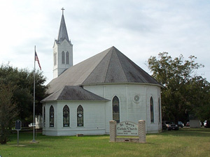
Text from the historical marker:St. Mary's Parish
Considered the oldest rural Catholic parish in Texas, St. Mary's was settled before the Texas War for Independence by such pioneers as James Brown, who was killed in the siege of the Alamo. First church edifice for St. Marys was built in 1840 under influence of missionary Fathers George Haydon and Edward A. Clarke, who also opened school for the settlement.
This was one of ten churches comprising Texas' First Diocese (Galveston) at its formation in 1847. Many priests' and sisters' vocations have come from this historic parish.
Note: After the marker was erected it was discovered that James Brown did not die at the Alamo.
Related Link
Seclusion is a decentralized community southeast of the intersection of Farm roads 530 and 2437, twenty miles southeast of Hallettsville in far eastern Lavaca County. During the 1840s settlers including John D. Ragsdale, Stephen Townsend, and Aaron Monroe secured grants as their headrights or bought land along the eastern bank of the Navidad River below its confluence with Ragsdale Creek. A Methodist church and a school called Boxville were established, but the community became known as Seclusion due to its isolation. A post office was established in 1879 and continued operation until 1914. The surrounding area is flat and poorly drained and, along the river, subject to floods. Heavy vegetation grows along the river, and cleared areas are used for pasture. Toward the eastern end of the community large acreages are given to rice. The discovery of oil and the Provident City gas field during the 1950s led to the construction of the Wilcox Gas Plant. No other businesses remain in Seclusion; and most of the community's students attend school in Hallettsville.
Shiloh
Speaks is on Farm Road 530 twenty miles southeast of Hallettsville in Lavaca County. In 1828 Jesse H. Cartwright received from the Mexican government a small grant of land on the east side of the Navidad River near the crossing of the Atascosito road. In 1835 Archibald S. White received a much larger grant that surrounded Cartwright's land and included most of the area that became Speaks. In 1866 the community, named Speaksville in honor of the owner of its single store, acquired a post office that remained in operation until 1876, when the name of the community was changed to Boxville. Under the new name the post office operated until 1882, when the store apparently closed. In 1928 J. W. Koonce reestablished the store and post office under the name of Speaks, and with the coming of a new wave of residents the community grew and prospered. By 1950 the settlement had two stores, a population of fifty, and the Speaks Community Church. The discovery of the Speaks oilfield and the Seclusion gas field raised the value of property in the area but not the size of the community. In 1987 the post office, a store, and the church remained, serving a dispersed population of about sixty. In 1990 the population was still reported at sixty.
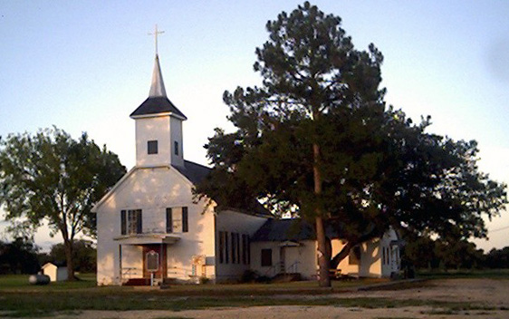
The Zion Lutheran Church was built in 1887 at the site of the Geiger Cemetery near Sublime.
In 1905 it was moved "board by board" to this site in Sublime and rebuilt exactly the same
Photo contributed by Norma Casey.
Click Photo for larger view
The Fernau Store in Sublime, Texas
Photo Contributed by Vera Fernau Muhr
Sublime is at the intersection of Farm roads 142, 146, and 125 and U.S. Highway 90-A, eight miles east of Hallettsville in eastern Lavaca County. In February 1838 Carney H. Coulter of San Augustine County received a land grant certificate on the basis of residency in Texas prior to the Texas Declaration of Independence. In March 1840 he located his land in two blocks running roughly east to west on the east bank of the Navidad River in Lavaca County. The area was covered by dense thickets of yaupon, wild grape, oak, and pecan and was known at the time as the territory of the "wild man of the Navidad." Most of the flood-prone area was used only as unimproved range for cattle. However, by 1875 a post office named Sublime was established near the river crossing to serve residents living east of the Navidad. In 1887 the San Antonio and Aransas Pass Railway completed its line through the old Coulter grant and connected Eagle Lake in Colorado County with Hallettsville in Lavaca County. Robert Miller donated land, primarily north of the tracks, for a townsite. Maintaining the name Sublime in hopes of attracting new residents, the community prospered as a center for trade among the Navidad settlements and attracted business from both Lavaca and Colorado counties. Although the community grew, by 1900 newer towns along the railroad, such as Rock Island and Sheridan, were attracting more residents because of their better farming conditions. By 1950 Sublime registered a population of eighty and two businesses. The railroad ceased operation at that time, but the improvement of U.S. Highway 90-A maintained the town's viability. In 1987 it had the post office, two churches, four businesses, and a population of seventy-five. Students attended school in Hallettsville, and the area's economy remained based on ranching. In 1990 the population was still seventy-five.
In A History of Lavaca County Paul C. Boethel writes: "Sublime . . . represented in the main a transfer of August Weller's general merchantile store from Wellersburg, D. Strunk's Store from Honey Creek, and Robert Miller's Store from Smoothing Iron."
Historical Marker
The text of the historical marker located about 1 mile southwest of Sublime on Alt US Hwy 90 at the east end of the Navidad River Bridge:
WILD MAN OF THE NAVIDAD
A mysterious runaway Negro slave who alternately terrified and aroused pity of settlers in this region for about 15 years.
The mysterious exile, at first with a companion, appeared along the Navidad bottoms about 1836. Hiding in trees during day, he stole into kitchens at night for food, but always left half. He also took tools, returning them later, brightly polished. Slaves called him "The thing that comes", fearing a ghost.
Captured in 1851, the wild man proved to be an African chief's son. Resold into slavery, he died peacefully as "Old Jimbo" in 1884.
Photograph contributed by Sarah Reveley. This marker is currently missing.
Related Links
Allen Cemetery
Geiger Cemetery
Smoothing Iron CemeterySublime
at TexasEscapes.comWild Woman of the Navidad
article by Murray Montgomery at TexasEscapes.comWild Man of the Navidad: truth or tall tale?
Victoria Advocate story by Randy Reese at Refugio County TXGenWeb site

Sweet Home is on Farm roads 318 and 531 south of Mustang Creek in west Lavaca County. It was named when the first settlers found the conditions there ideal for home life. The first post office was established in 1852, and in 1860 George West established a store, a hotel, and stables. During the Civil War the town served as a winter camp for freight and cotton wagontrains carrying supplies from Alleyton to Brownsville, the only Confederate port remaining open during much of the war. Around 1873 Czechs and Germans began to move into the community. In 1887, when the San Antonio and Aransas Pass Railway built five miles south of the town, West sold his buildings to Jan Matusek and moved his store to the railroad. Other settlers from the old town joined him, and by 1890 the new community of Sweet Home had six stores. The railroad closed its agency in 1937. In 1948 the town had twelve stores, a recreation hall, and a church for its population of 350. In 1986 the reported population was 360, and the town had three businesses, a post office, a school and two cemeteries. The population was still 360 in 1990.
Paul Boethel writes in A History of Lavaca County: "[Sweet Home] is the home of such prominent cattlemen as Willis McCutcheon, John Bennett, Sol West, George West, Ike West, and the Allen brothers. In 1884, general merchandise stores were operated by C. & F. Patton, and H. & R. Saunders; a mill and gin were operated by Hicks and Saunders. At that time, it had a school, a church, and three doctors."
Related Links
Sweet Home
Bennett Cemetery
Mount Zion CemeterySee Related Link at The Handbook of Texas Online:
Most of the information on this page comes from The Handbook of Texas Online.
Do you have photographs you would like to share?
From the historical marker at Velehrad:
SITE OF VELEHRAD SCHOOL
The Velehrad community was settled in the 1850s; the settlement was named Velehrad, or "Big Castle" for the Czech city of that name. The first marked burial in the local cemetery dates to 1855. From its earliest days, the community organized school classes in private homes. Children were taught in Czech because most area settlers were Czech immigrants. As the area population grew to 50 or 60 families, the settlers made plans to build a schoolhouse on land west of the cemetery. As was common, the one-room structure was placed on the lower part of the tract so that the building would be as close as possible to a water source. Classes were conducted in English when the school opened its doors about 1879. In 1887 school trustees sold off one acre of land which later became the site of S.P.J.S.T. Lodge Hall No. 19. By the turn of the 20th century, the area's population was growing. The Kahanek family operated a cotton gin just north of the school property in Fayette County. In 1924 the Velehrad School District traded land for 5.5 acres around their school that included the S.P.J.S.T. Lodge Hall property. The schoolhouse was moved onto the new land to be used as a vocational workshop, and a new two-room school with a stage was erected on the original part of the property to accommodate the increasing student population. Trustees added another room in the early 1930s. As the area population declined in the next decades, Velehrad School closed and its students were transferred to the Moravia School District No. 7. The Moravia District, in turn, closed to consolidate with Hallettsville schools in 1972. (1999)
Photo contributed by Gary McKee
Vienna
From the historical marker 11 miles southeast of Hallettsville at the intersection of FM 530 and CR 124:
VIENNA (CHENEY SETTLEMENT)
The community of Vienna has roots that reach back to the Republic of Texas. Maryland native John Cheney (1796-1868) brought his family to Texas in 1830 when Native Americans, including his wife Lucy, were expelled from their home in Georgia. Cheney served as Constable and Justice of the Peace in what was then Colorado County. His home on the west bank of the Navidad River, once including more than 7,000 acres, became known as Cheney Settlement. The Cheney family sold off portions of the family farm, and an influx of German, Austrian and Czech immigrants arrived. In 1873, Benjamin Milby opened a post office named Vienna in honor of the Austrian capital. In the 1880s, Pat Carvelle gave land for a school, which the community built with lumber hauled from Schulenburg. John Mixon operated a general store and the post office from 1885 to 1906, followed by postmaster Louis Teltschick, who also built and operated a cotton gin, sawmill, grist mill and blacksmith shop. Vienna was also a popular picnic spot in the early 20th century, with picturesque crossings of the Navidad River nearby. A July 1940 flood severely damaged the gin complex, though, and sent the Louis Teltschick family to the upper portion of the gin for shelter. The congregation of Vienna Baptist Church, founded at Seclusion (6 mi. SE) in the 1880s, moved next to the school in about 1915, the same year the post office closed. During the 1940s, the gin, school and several stores closed, and construction of Farm to Market Road 530 from Hallettsville to Edna in the 1950s hastened the dispersal of Vienna. Today, Vienna Baptist Church (1 mi. NE) is the only surviving building of this once viable rural community. (2006)
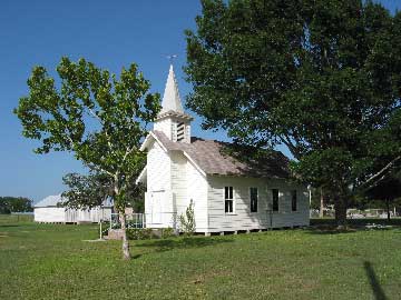
Vsetin is at the intersection of Farm Road 2314 and county roads 138 and 142, six miles northeast of Hallettsville in northeastern Lavaca County. The land in the area was originally granted by the Mexican government to Elenor Living in 1831. Until the 1880s it remained in relatively large blocks divided among only a few owners. During the 1880s many small ethnic communities, among them Vsetin, sprang up in Lavaca County for immigrants from Bohemia and Moravia. The community developed around the Evangelical Unity of the Czech-Moravian Brethren Church, an independent Protestant congregation associated with the Unity of the Brethren. The church was first built in 1894; it was rebuilt in 1954 and has two cemeteries. The larger cemetery dates from 1888; the smaller first recorded a burial in 1895. Throughout the first half of the 1900s, cotton was the primary crop. However, with the local decline in cotton during the 1950s, most of the area land reverted to pasture, with some in cultivation for corn and hay. Vsetin is primarily an ethnic and religious community, and most business is conducted in nearby Hallettsville.
Vsetin Church
Photo contributed by Norma Casey.
BIBLIOGRAPHY: Christian Sisters Union Study Committee, Unity of the Brethren in Texas, 1855-1966 (Taylor, Texas: Unity of the Brethren, 1970). Sammy Tise, Lavaca County Cemetery Records, Vol. 1 (Hallettsville, Texas, 1983).
Jeff CarrollRelated Links
Wied is on Farm Road 1891 just north of U.S. Highway 90A, midway between Hallettsville and Shiner in west central Lavaca County. The first settlers in the area were John Smeathers, who arrived in 1832, and Francis Smith, who arrived in 1835. Soon after Texas independence Anthony Brown and Moses Mitchell joined them. These Anglo-Americans from the southern United States found that the well-watered and well-drained rolling prairieland between Ponton and Smeathers creeks provided excellent pasture for horses and cattle and, when cultivated, produced good crops of cotton and corn. By 1873 German immigrants had replaced most of the original occupants and divided the ranches into farms. A community with a blacksmith shop, a store, and a cotton gin developed on land owned by the Wied brothers and took their name. A post office operated in the store from 1889 until 1906. Czech immigrants arriving in the 1880s and 1890s soon balanced the German population. In the 1890s Wied had a population of forty. F. F. Kuehn operated a private school in the community until 1895, when F. W. Wunderlich donated land for a public school. By 1919 there were enough Czech Catholics to build St. Ludmilla's Catholic Church. Cotton supported the local economy, which rose and fell with supply and demand. Wied had a population peak at 100 and three businesses in the early 1940s. By 1950 the population had fallen to forty, where it remained through the late 1960s. In 1950 the store and gin remained, but the decline in cotton production soon afterward closed them, and residents traveled to Hallettsville or Shiner for shopping. From 1968 to 1990 the population of Wied was sixty-five. In 1987 a community hall and large commercial nursery marked the site of the community.
The tiny settlement of Williamsburg is located off US Hwy 77 about four miles south of Hallettsville in central Lavaca County. The village was settled near Rocky Creek in 1876 and named after its founder John Williams. Williams owned a gristmill and general store and also served as an early postmaster. In 1884 the Texas State Gazetteer reported a population of 120. At that time Williamsburg (spelled Williamsburgh) had a school, church, steam sawmill, and cotton gin. Residents included physician W. D. Burt, carpenter W. P. Gainer, blacksmith B. J. Grace, and teacher Miss H. D. Lay. Williamsburg's population increased to 150 in 1890 and was 200 by 1896, when the town supported both Catholic and Methodist churches. By 1910, however, the post office closed, and the community suffered a decline. As late as the 1930s the area consisted of farms and a rural school, but no population statistics were available. Williamsburg still appeared on highway maps in the 1980s, and the Hallettsville Municipal Airport was located in the vicinity.
Witting is at the intersection of Lavaca County Road 277 and Farm Road 340, midway between Hallettsville and Moulton in northwestern Lavaca County. On September 15, 1831, Edwin Richeson, a member of Green DeWitt's Gonzales colony, received a land grant from the Mexican government between Smeathers Creek and the south bank of the Lavaca River. The land was well-watered rolling prairie suited for pasture and cultivation of cotton and corn. Following the Civil War much of the land became small farms, and German immigrants began replacing the earlier Anglo-American residents. A community with a store operated by H. Garbade, a blacksmith shop, and a cotton gin grew near the center of Richeson's grant and was named for George Witting, a large landowner. In 1880 the settlement acquired a post office, which continued in operation until 1906. A school was built nearby, and the community prospered in relation to the supply and demand for cotton. In 1896 the German Schuetzen-Verein built a community hall, and by 1928 there were enough residents to build and support a German Lutheran church. A Catholic church followed in 1944 for the growing Czech population. By 1950 Witting had seven stores, a community hall, two churches, a school, a cotton gin, and seventy residents. A decline in cotton production during the 1950s signaled a decline in the community. The gin closed, as did several of the stores. School consolidation sent students to both Hallettsville and Moulton. By 1987 only one business remained, supported by a population of ninety and a strong sense of community. In 1990 the population was still ninety.
Witting Evangelical Lutheran Church
Colorado Citizen
2 Feb 1882, page 3WITTING POSTOFFICE.—In our neighboring county of Lavaca is a league of land, formerly the property of Mr. Geo. Witting, of this place, which is being rapidly settled up by honest, industrious farmers, mostly German. They are fast redeeming the land from dormant reproductiveness, and causing it to "blossom as the rose." Care has been taken that none but law-abiding, first-class citizens shall obtain a foot-hold therein. The proprietor is not compelled to dispose of an portion of it, and good qualities in the character of the purchaser are a sine qua non. The settlement has all conveniences, a post office. schoolhouse, divine services, and educational factilites of a fine order. Soon the settlers will have a large and industrious community of good citizens which community is bound to exert a healthful and good influence upon adjacent neighborhoods. The post office has been named through the instrumentality of Congressman Wash Jones.
Worthing is near the intersection of U.S. highways 90A and 77A, four miles west of Hallettsville in central Lavaca County. On May 8, 1832, John Smeathers, a member of DeWitt's colony, received a grant to lands on Smeathers and Rocky creeks from the Mexican government. Francis Smith, whose grant joined his on the west, followed him on March 23, 1835. The land was well-suited for producing corn and cotton as well as for use as pasture. During and after the Civil War much of this land became small farms, and German and Czech immigrants began replacing earlier Anglo-American ranchers. In 1882 Joe Orsak built a cotton gin, and A. H. Worthing built a store to serve the farmers. Worthing's store became a post office that year, and the community took his name. The post office functioned until 1906, when mail was routed through Hallettsville. By 1887 the Czechs had built the Vseyhrad (High Castle) school a mile north of Worthing's store. The local economy fluctuated with the supply and demand for cotton. By 1919 the St. Augustine Catholic Church was built. By 1950 Worthing had a population of forty and two businesses. The decline of cotton planting in the 1950s signaled the decline of Worthing. By 1987 no businesses remained, although the community claimed a population of about fifty-five. In 1990 the population was still fifty-five.
Related Link